


Lot 60013 – Provincial Map: c1640 An antique regional map of the southern part of Ireland, which is one of a set of maps which was published in Gerard Mercator’s atlas « Historia Mundi or Mercators Atlas » and printed by T. Cotes. Unc
Lot 60013 – Provincial Map: c1640 An antique regional map of the southern part of Ireland, which is one of a set of maps which was published in Gerard Mercator’s atlas « Historia Mundi or Mercators Atlas » and printed by T. Cotes. Unc
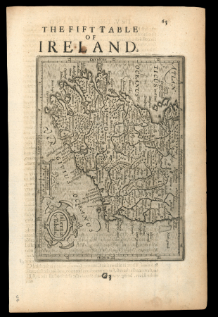


Lot 60013 – Provincial Map: c1640 An antique regional map of the southern part of Ireland, which is one of a set of maps which was published in Gerard Mercator’s atlas « Historia Mundi or Mercators Atlas » and printed by T. Cotes. Unc
Ireland » Historical Documents
Cher collectionneur, nous vous présentons le lot 60013 que vous pouvez maintenant ajouter à votre collection de Ireland » Historical Documents. Si vous avez des questions sur nos timbres ou nos lettres, n’hésitez pas à nous contacter ici.
Prix réalisé
100 GBP
Estimation
100 – 150 GBP
Date de vente
mar. 9 déc. 2025 à 14:00 (Europe/Zurich)
Description
Provincial Map: The Fift Table of Ireland – Hiberniae v Tabula – Gerard Mercator – c1640 An antique regional map of the southern part of Ireland, which is one of a set of maps which was published in Gerard Mercator’s atlas « Historia Mundi or Mercators Atlas » and printed by T. Cotes. Uncoloured, a fine and clear impression. Approx 185 mm x 135mm.
Vente aux enchères
Catalogue
Des scans et images complémentaires sont ajoutés de manière continue.
Si vous avez besoin d’images supplémentaires et que vous ne trouvez pas les documents recherchés en ligne, n’hésitez pas à nous contacter.
Pour toute information complémentaire concernant ce lot, veuillez nous contacter.